Contact

Center for Asian Studies CASE Building, Suite E330
366 UCB
Boulder, CO 80309-0366
China_Made@colorado.edu
Partners
![]()
![]()
![]()

New Grounds: Infrastructuring the Central Plains of China
Leonardo Ramondetti, August 2020
Download the English PDF version here (938 KB); 点击下载电子中文版(825KB)
Since 2016, my research has focused on the process of urbanization occurring in the Central Plains of China, in Henan province. My study starts from the premise that understanding urbanization requires investigating how physical spaces, especially infrastructure, are designed, built, practiced and used there. It sets out to provide a synthetic interpretation of this process based on detailed descriptions of the relationships between the current policies, economies and societies, and transformations affecting the physical space and the infrastructural systems. This interpretation seeks to instigate a debate regarding what Chinese urbanization reveals about building and living in contemporary cities both in and beyond the Chinese context. To achieve this, I consider the past urban conditions of the area, their current state and ongoing transformations. This investigation has been conducted by examining official data and current literature on the process of urbanization in China and, more specifically, in Henan province. At the same time, between January 2016 and May 2019, I carried out an empirical study over three periods of field research in China. Drawing on the data collected in these investigations, I developed an analytic that builds on theoretical frameworks in fields such as architecture, urban studies, and geography to consider contemporary physical spaces and urbanization processes occurring worldwide. In particular, I focus on: the processes of suburbanization in North America (Phelps, 2015; Rowe, 1991; Thün et al., 2015), urban diffusion in Europe (De Geyter, 2002; Sieverts, 2003; Viganò et al., 2016) and studies of contemporary infrastructure and logistic spaces (Brenner, 2014; Easterling, 2016; Koolhaas et al., 1995). As with the present urbanization of the Central Plains of China, the ‘city’ resulting from these three processes appears to be elusive at first glance. However, the resulting landscape interpretations have established a shared language through which to understand how different spatial systems work in terms of relations between physical spaces and socio-economic and political conditions (Duncan & Duncan, 2010).
The adoption of such a methodological strategy is twofold: on the one hand I try to move beyond the exceptionality of Chinese urbanization (Governa & Sampieri, 2019), and on the other I seek to re-materialize the subject of study (Amin & Thrift, 2002). While most of the literature on Chinese urbanization primarily focuses on demography, economy and policies, I argue that this process cannot be regarded merely as an ‘above ground’ phenomenon impacting the socio-economic sphere (Armstrong & McGee, 1985). On the contrary, the ground of Chinese cities is a densely constructed new space hosting novel artefacts and infrastructure that need to be investigated: new economies are closely linked to new infrastructures, logistic platforms, industrial areas, tourist sites, new housing, and areas for leisure, wellbeing and cultural activities; and new policies address the need to preserve farmland, curb pollution, and capitalize on specific sites (Bonino et al., 2019; Oakes, 2019). In light of this, the current infrastructuralization of Chinese cities offers a unique opportunity to investigate a process of urbanization in the making. Furthermore, the new infrastructural systems have constitutive technical dimensions that can be engaged regardless of the cultural perspective (Lyster, 2016). Of course, this does not mean regarding infrastructure as a sort of ‘neutral network’ capable of obliterating all local specificities thought standardization (Ben-Joseph, 2005). On the contrary, these ‘sociotechnical mediums’ reflect socio-economic contingencies, political ambitions and cultural values while shaping new modes of living, constructing, occupying and consuming the land (Corner, 2014; Graham & Marvin, 2001).
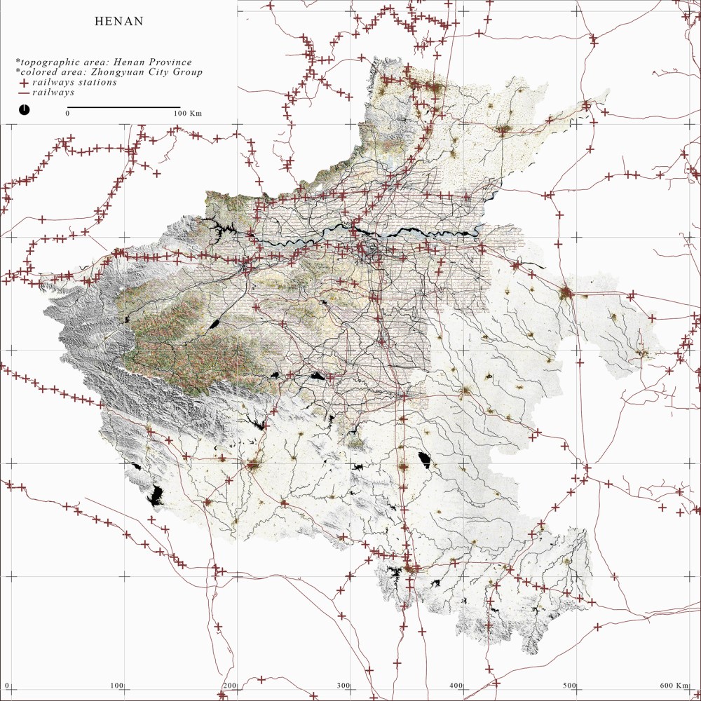
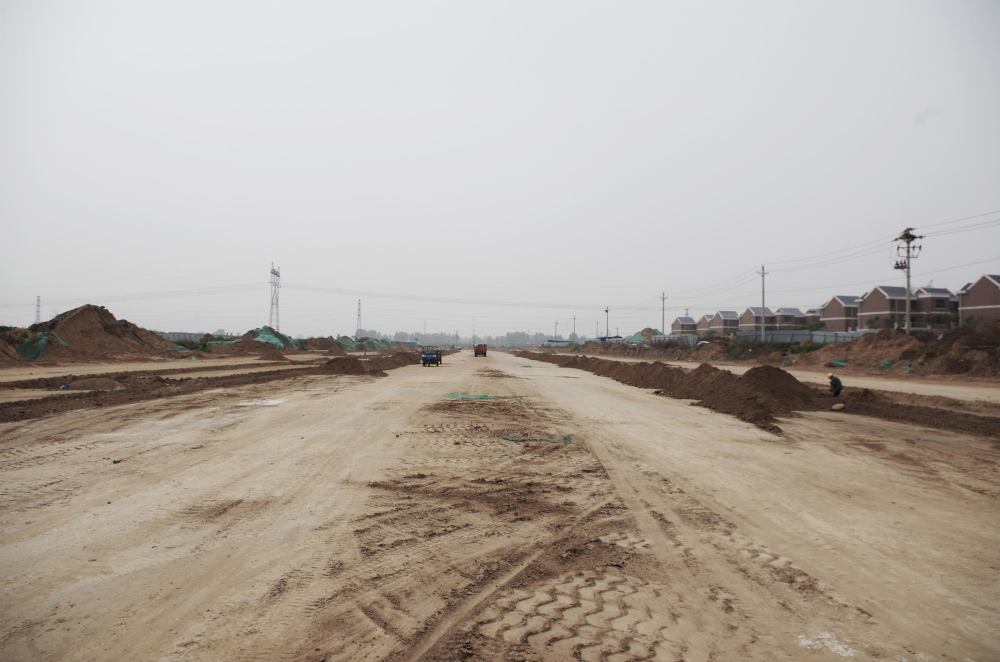
I focused my study on the Central Plains of China because of the radical transformations in progress which are dramatically changing this space. Although this is still a little-studied region, it is now one of the main test beds for local governments, urban planners and developers to experiment with new urban policies and new ways of organizing the land. Like most of the territory of inland China, the Central Plains used to be largely characterized by minor agglomerations built over a long period of time and made up of small-scale infrastructures that supported a diffuse urbanization. Due to the process of large-scale territorial infrastructuralization, that is the construction of transport, ecological and energy infrastructure as drivers of a process of urbanization and landscape restructuring, in the last three decades this area has been drastically transformed: high-speed railways, highways, canals, parks, airports and grids have been built. As a result, the Central Plains is now a regional-level urban agglomeration, the so-called Zhongyuan City Group, one of the most densely populated areas in the world: an area of 58,400 square kilometers made up of nine prefecture-level cities, 23 cities and 413 townships. The space produces 3.06 percent of China’s GDP and is home to 45.5 million inhabitants (3.39 percent of the population of China) of which 30 percent (13.7 million) are considered ‘urban population’ (Fang & Yu, 2016). Today, inside this area, a great process of spatial restructuring is gaining momentum. The current policies aim to urbanize 4,902 square kilometers (an area four times the size of New York City) to host new inhabitants, new economies and to promote new ways of living and social constructions. This process is supported by an ever denser and diversified network of infrastructure which is radically changing the way in which spaces are designed, constructed, inhabited and perceived.
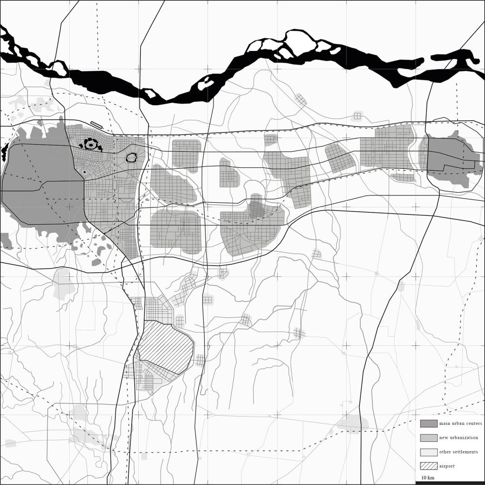
This is particularly evident when investigating the area of the Zhengbian New District: a new urban development promoted by Henan province and the municipalities of Zhengzhou and Kaifeng to unify the two cities (Wu, 2015). The plan, drafted in 2010 by the international firm ARUP, envisages a linear city along the main infrastructural axes and ecological corridors (ARUP Engineering Consulting Company et al., 2010). This wide-area system aims to distribute a large variety of urban materials and land-uses over a linear distance of 80 kilometers and to reorganize a total area of 40 square kilometers, which is currently populated by 4.5 million inhabitants (Zhengzhou Municipality, 2009). In the last decade, the plan has been progressively implemented, driven mainly by the construction of new infrastructure. As an example, in the area of the Zhengzhou municipality, the total kilometers of roadway built per year has increased from 1,272 kilometers in 2010 to 2,101 kilometers in 2018; consequently, the overall paved area for infrastructural uses has risen from 29,220 to 58,210 thousand square meters. Over the same time period, the water supply system has also been expanded, passing from 2,360 to 4,420 kilometers (Zhengzhou Municipal Statistics Bureau, 2018). Most of this improvement occurred in the area of Zhengbian New District.
The result of this infrastructure-driven urbanization is an extremely dense landscape composed of heterogeneous urban materials positioned next to each other. This loose, deformable space is capable of containing anything and everything: airport cities, university towns, Economic Technology Development Zones, logistics hubs, technical spaces for agricultural production, Central Business Districts, and leisure areas. However, due to the novel conditions of this landscape, these cannot be considered merely technical spaces for production, as they play host to a myriad of diverse functions; for instance, 300,000 people both work and live in the Foxconn Science Park, producing 500,000 mobile phones a day at a rate of 350 phones a minute (China Labor Watch, 2019). Similarly, the university town in the Zhengdong New District contains more than twelve campuses to accommodate about 200,000 people that work and live in an area of more than 13 square kilometers (Li et al., 2010).

In the same way, the new infrastructure is radically altering how spaces are inhabited. New housing is being built everywhere, promoting new practices and ways of occupying the land. This is particularly evident when investigating the fringes of the Zhengbian New District. In these agricultural areas, which are to be preserved as an ecological corridor for agrarian production, there are not just ancient and modern agricultural villages, but also newly-built agricultural towns developed by the New Socialist Countryside program, and compounds built by real estate companies. These settlements manifest a shift in imagining how people inhabit rural areas. This is clearly visible not only in the new housing typologies adopted, but also new the facilities and welfare spaces, such as schools, hospitals, parks and areas for sport activities (Lee, 2016).
This brief description highlights the complexity and contradictions of the landscape transformations occurring in the Central Plains of China. This upheaval leads to further questions and conflicts that can reveal a great deal regarding the contemporary city, and have, still, largely to be explored. Above all, the relationships this new infrastructure-driven urbanity establishes with pre-existing settlements, national and international trading routes, Chinese and global labor systems may shed light on the multi-scalar logics that characterize the urban realm. Hence, it is possible to reconceptualize the Chinese city, not as unique, but as just one of the multiple spaces that compose today’s urban realm. Similarly, understanding how new infrastructure organizes and structures the landscape can help us to build new discourses and projects on the city, and open up to new imaginaries for designing the living environment
新基地:基础建设中原
自2016年起,我的研究聚焦发生在中国河南中原的城市化进程。该研究始于一个前提:理解城市化需要我们调查物理空间,特别是基础设施,是如何被设计、建造、运行和使用的。它着眼于对当前政策,经济和社会之间的关系以及影响物理空间和基础设施系统的变革的详细描述,从而对该过程进行综合解释。这种解释旨在引发一场有关中国城市化所揭示出的关于修建和居住于中国境内外当代城市中的辩论。为了达到这个目的,我参考了该区域过去的城市化基础,其当下的境况还有正发生的转变。这个调查是通过研究关于中国特别是河南省城市化进程的官方数据和最新文献进行的。同时,在2016年1月到2019年5月期间,我通过田野调查进行了3次实证性研究。采用通过调研收集到的数据,我形成了一种以建筑学,城市学和地理学理论框架为基础的研究方式来学习现代化物理空间和发生在世界各地的城市化进程。我尤其关注以下几点:北美洲的郊区化进程(Phelps, 2015; Rowe, 1991; Thün et al., 2015 ),欧洲的城市扩散(De Geyter, 2002; Sieverts, 2003; Viganò et al., 2016 ),与对现代基础设施和物流空间的学习(Brenner, 2014; Easterling, 2016; Koolhaas et al., 1995 )。就像目前中原地区的城市化一样,通过这三个过程产生的“城市”乍一看似乎难以捉摸。但是其最终的景观解释建立了一种共同的语言,通过它可以理解不同的空间系统是如何根据物理空间与社会经济和政治条件之间的关系而工作的(Duncan&Duncan, 2010)。
采取该方法策略的原因有两层:一是我试图超越中国城市化的独特性 (Governa & Sampieri, 2019);另一方面是我希望为研究主题再次赋予实质性(Amin & Thrift, 2002)。尽管多数有关中国城市化的文献都聚焦于人口统计,经济与政治学,但我认为城市化这一进程不能仅仅被看作一个影响社会经济领域的“地表”现象(Armstrong & McGee, 1985)。相反,一个被密集修建并存放着新奇人工制品与基础设施的新空间,中国城市的地表需要被审视:新经济与新基础设施,物流平台、用业园区、旅游景点,新住宅区和休闲健康文化场所紧密相连;同时新的政策解决保护耕地,减少污染,和利用特定地点的需求(Bonino et al., 2019; Oakes, 2019 )。在此情况下,当下中国城市的基础设施化为研究城市化进程提供了的一个独特的机会。此外,作为新的基础设施系统的构成部分,无论文化角度如何,技术维度都可以成为研究的一部分(Lyster, 2016)。当然,这并不意味着基础设施将被当作有能力通过标准化消除所有本地特性的“中立的网络”(Ben-Joseph, 2005 )。相反,这些“社会技术媒介”在反映社会-经济偶然性,政治抱负和文化价值观的同时也在塑造着新的居住,建设,占领和消费土地的方式(Corner, 2014; Graham & Marvin, 2001 )。
我将研究置身于河南中原是因为当地正在发生翻天覆地的空间变化。尽管这个区域还未被详尽研究,但它现在是本地政府,城市规划师和开发商尝试新城市政策和土地管理方式的主要实验场之一。类似于中国内陆的大部分领土,中原地区过去的主要特征是长期以来修建的小规模聚集区,这些集聚区由支持分散式城市化的小型基础设施所组成。由于大规模领土性基础设施的修建 – 即推动城市化和景观改造的交通,生态和能源基础设施 – 该地区因修建的高速铁路,高速公路,运河,公园,机场和电力系统在过去三十年间发生了巨大的变化。结果是,河南中原成为了一个区域级的城市聚集区,所谓的中原城市组,世界上人口最密集的居住区之一:面积为58400平方公里的区域由9个地级市,23个城市和413个乡组成。该空间生产出占中国3.06%的GDP,拥有4550万居民(占中国总人口的3.39%),其中30%(1370万)被视为“城市人口”(Fang & Yu, 2016 )。如今,在该区域内部,巨大的空间重组过程正在蓬勃发展。当前的政策计划将4902平方公里城市化(相当于4个纽约市的大小)以容纳新居民和新经济并促进新的生活方式和社会建设。这个过程得到了日益密集和多元化的基础设施网络的支持,该网络从根本上改变了空间被设计,构造,居住和感知的方式。
在调查郑汴新区时 – 由河南省政府与郑州和开封市政府共同推动的两城统一的新城市发展项目 – 这一点尤为明显(Wu, 2015)。该计划由国际公司ARUP于2010年起草,设想了一条沿主要基础设施轴线和生态走廊而生的线性城市(ARUP Engineering Consulting Company et al., 2010)。这个广域系统旨在80公里的线形距离上分布大量不同城市材料和土地用途,并重组目前有450万人居住的面积为40平方公里的区域(Zhengzhou Municipality, 2009)。在过去10年间,主要受新基础设施建设的推动,该计划正在有序地逐步进行。例如,在郑州市区域内,每年平均修建的公路长度从2010年的1272公里上升到了2018年的2101公里;因此,为基础设施实施所铺好的区域总面积也从2922万平方米增长到了5821万平方米。在同一时间段内,供水系统也实现了从2360千米到4420千米的扩张(Zhengzhou Municipal Statistics Bureau, 2018)。大部分的改善都发生于郑汴新区内。
由彼此相邻的异质城市材料组成的极其密集的景观是基础设施推动的城市化的结果。这个松散的,可变形的空间能够容纳任何事物:机场城市,大学城,经济科技发展区,物流中心,农业生产技术空间,中央商业区和休闲场所。但是,正因为这个景观新奇的性能,这些地方不能仅仅被认为是为生产活动而生的技术性空间。除了生产,他们还承载了无数种多样的功能。例如,30万人以每分钟350个每天50万个手机的生产速度在富士康科技园区生活和工作(China Labor Watch, 2019 )。类似的是,郑东新区的大学城涵盖超过12个校区,为约20万在这个超过13平方公里区域里工作和生活的人们提供住宿(Li et al., 2010 )。
新的基础设施也以同样的方式从根本上改变了人们居住的方式。四处修建的新房推动了占领土地的新方式。这个发现在调查郑汴新区边缘地带时尤为明显。在这些为农业生产而保留的生态走廊农业区里不仅有古老和现代的农村,还有由新社会主义农村项目开发新建的农业小镇,以及房地产公司修建的院落。这些定居点体现了人们想象农村生活方式的转变。这不仅在采用的新住房类型中清晰可见,在新的设施与福利空间中也很明显,例如学校,医院,公园和体育活动场所(Lee, 2016)。
该简短的描述强调了发生在中原地区景观转变的复杂性与矛盾性。该巨变引发了进一步的问题与冲突。这些问题和冲突能揭露有关当代城市的很多东西及其尚未被探索的地方。更重要的是,这段由新基础设施推动的城市化与已存定居点,国家及国际贸易路线,中国与全球劳工系统建立起的关系可能会阐明描述城市领域的多维度逻辑。
因此,重新概念化中国城市是可能的 – 中国城市不是一个独特的概念,而是组成当下城市领域多数空间的其中之一。同样,理解新的基础设施如何组织和构建景观能帮助我们在城市里建立新的话语和项目,并打开设计居住环境的新想象力。
Leonardo Ramondetti is an architect and urbanist working at the intersection of urbanisation theory, design and geospatial analysis. He received his Ph.D. in Urban and Regional Development from Politecnico di Torino and Università di Torino in June 2020. His recent work includes contributions in the research CeNTO (Chinese New Town) and the publication The City after Chinese New Towns (M. Bonino et al., Birkhäuser, 2019). He holds a master degree in Architecture Construction City at Politecnico di Torino with highest distinction in 2014.
Leonardo Ramondetti 是一位建筑师和城市规划者。他的研究交叉于城市化理论,设计和地理空间分析之间。他于2020年6月获得意大利杜林理工大学城市与区域发展的博士学位。Leonardo的近期研究包括对中国新城研究的贡献与发表的期刊论文,The City after Chinese New Towns (M. Bonino et al., Birkhäuser, 2019) 。2014年,他获得了由意大利杜林理工大学授予的城市建筑建造荣誉硕士学位。
Works Cited
Amin, A., & Thrift, N. (2002). Cities: Reimagining the urban. Polity Press.
Armstrong, W., & McGee, T. G. (1985). Theatres of Accumulation: Studies in Asian and Latin American Urbanization. Routledge Kegan & Paul.
ARUP Engineering Consulting Company, Zhengzhou City Planning and Design Institute, & Kaifeng City Planning and Design Institute. (2010). Master Planning of Zhengbian New District (2009-2020). Atlas.
Ben-Joseph, E. (2005). The Code of the City: Standards And the Hidden Language of Place Making. MIT Press.
Bonino, M., Governa, F., Repellino, M. P., & Sampieri, A. (2019). The City After Chinese New Towns. Spaces and imaginaries from contemporary urban China. Birkhäuser Architecture.
Brenner, N. (Ed.). (2014). Implosions/Explosions: Towards a Study of Planetary Urbanization. Jovis.
China Labor Watch. (2019). iPhone 11 Illegally Produced in China. Apple allows supplier factory Foxconn to violate labor laws (p. 51). China Labor Watch. http://www.chinalaborwatch.org/upfile/2019_09_06/Zhengzhou%20Foxconn%20English%2009.06.pdf
Corner, J. (2014). The Landscape Imagination: Collected Essays of James Corner 1990-2010. Princeton Architectural Press.
De Geyter, X. (Ed.). (2002). After-Sprawl: Research On The Contemporary City. NAi Publishers/Rotterdam & deSingel International Arts Centre, Antwerp.
Duncan, N., & Duncan, J. (2010). Doing landscape interpretation. The SAGE Handbook of Qualitative Geography, 225–247.
Easterling, K. (2016). Extrastatecraft: The Power of Infrastructure Space. Verso.
Fang, C., & Yu, D. (2016). China’s New Urbanization: Developmental Paths, Blueprints and Patterns. Springer.
Governa, F., & Sampieri, A. (2019). Urbanisation processes and new towns in contemporary China: A critical understanding from a decentred view. Urban Studies, 2–17.
Graham, S., & Marvin, S. (2001). Splintering Urbanism: Networked Infrastructures, Technological Mobilities and the Urban Condition. Routledge.
Koolhaas, R., O.M.A, & Mau, B. (1995). S, M, L, XL. Monacelli.
Lee, C. C. M. (2016). Common Frameworks: Rethinking the Developmental City in China. Harvard University Graduate School of Design.
Li, K., Administrative Committee of Zhengdong New District, & Zhengzhou Urban Planning Bureau (Eds.). (2010). The Urban and Architectural Design of Zhengdong New District (Vol. 4). China Construction Industry Press.
Lyster, C. (2016). Learning from Logistics. Birkhäuser.
Oakes, T. S. (2019). China’s urban ideology: New towns, creation cities, and contested landscapes of memory. Eurasian Geography and Economics, 1–22.
Phelps, N. A. (2015). Sequel to Suburbia: Glimpses of America’s Post-Suburban Future. MIT Press.
Rowe, P. G. (1991). Making a Middle Landscape. MIT Press.
Sieverts, T. (2003). Cities without cities: An interpretation of the Zwischenstadt. Routledge.
Thün, G., Velikov, K., McTavish, D., Ripley, C., McMorrough, J., & Fishman, R. (2015). Infra-Eco-Logi Urbanism: A Project for the Great Lakes Megaregion. Park Books.
Viganò, P., Fabian, L., & Secchi, B. (Eds.). (2016). Water and asphalt: The project of isotropy. Park Books.
Wu, F. (2015). Planning for Growth: Urban and Regional Planning in China. Routledge.
Zhengzhou Municipal Statistics Bureau. (2018). Zhengzhou Statistic Data. http://tjj.zhengzhou.gov.cn/
Zhengzhou Municipality. (2009). Solicitation for Spatial Development Strategic Planning Scheme of Zhengbian New District. Zhengzhou Municipality.
Center for Asian Studies CASE Building, Suite E330
366 UCB
Boulder, CO 80309-0366
China_Made@colorado.edu
![]()
![]()
![]()
